The “Gospel Temperance Railroad Map” is an example of an allegorical map. It was published in 1908 by G. E. Bula and looks very much like the typical American railroad map of its day. It presents the traveler with three main lines diverging from Decisionville in the State of Accountability at the left-hand side of the map. The routes of the lower two lines, the Way That Seemeth Right Division and the Great Destruction Way Route, pass at first through towns representing relatively minor vices and self-deceptions of alcohol use, but lead inevitably to more serious “states” of Depravity, Intemperance, and Bondage. A River of Salvation offers hope for some, but those who stubbornly remain on the path of drink and debauchery end, without escape, in the City of Destruction. The upper line from Decisionville, the Great Celestial Route, is not without its trials, represented by such station stops as Bearingcross, Abandonment, and Long Suffering; but the final destination, The Celestial City, is clearly more desirable than its counterpart.
See also "Mapping", Episode 110 of This American Life: Five ways of mapping the world. One story about people who make maps the traditional way—by drawing things we can see. And other stories about people who map the world using smell, sound, touch, and taste. The world redrawn by the five senses.
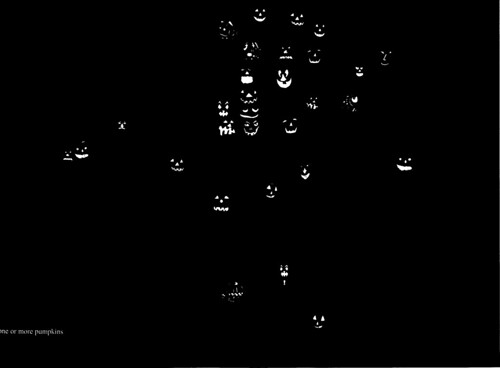
In particular, see Act One, with Denis Wood and his maps, like this one:
On Halloween 1982, I walked around the neighborhood and photographed all the jack-o'-lanterns. In most cases, the photograph is of the pumpkin on the porch at that location, but where my photographs didn’t turn out, we duplicated an image from another porch.
What is a Map? |